Permanent Orienteering Courses
- Home >
- Information >
- Permanent Orienteering Courses
This page has some information on where you can find Permanent Orienteering Courses in WAOC's area.
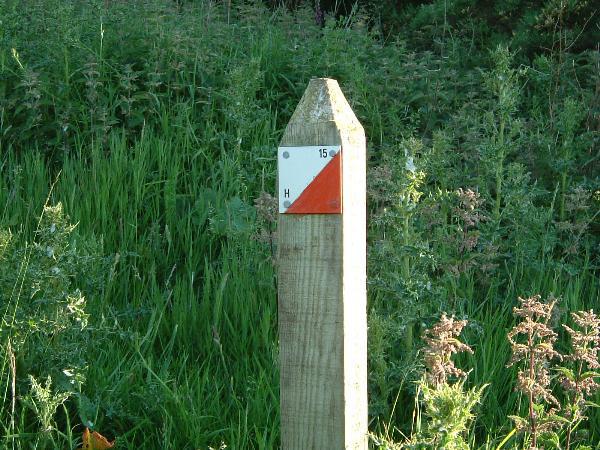
POC post
What is a Permanent Orienteering Course?
A Permanent Orienteering Course (POC) consists of a map of an area with a series of ‘controls’ marked on it. These correspond to control markers on the ground such as posts or orange and white labels.
The aim is to navigate around the course, practising map reading and exploring the area at your own pace whether that be walking as a family, jogging with your pet dog, or livening up some run training.
Permanent courses are usually set up in areas which are easily accessible to the public, and where there is somewhere such as an information kiosk where you can obtain a copy of the map. (There may be a small charge for the map to cover costs of printing and to contribute to maintaining the course). We are trying to make all maps available on-line too.
The control markers carry a number which matches the control code on the map (so you know you have found the right site). They usually also carry a letter code. The letter code is not shown on the course map, and can be written down as proof that you found the right location.
Local Permanent Orienteering Courses
All the WAOC permanent orienteering courses can be found on the MapRun.uk website.
Ferry Meadows Country Park (Peterborough Area)
Click here for location map.
Information about Ferry Meadows Country Park can be found on the Nene Park Trust website.
The map can be downloaded from the Ferry Meadows POC page on the MapRun.uk website.
Status (as of 9th June 2020):
- No plaque at Start/Finish which is at the visitor centre
- Posts have a letter on, but not the control number
Crown Lakes (Peterborough Area)
Click here for location map.
The map can be downloaded from the Crown Lakes POC page on the MapRun.uk website.
Status (as of 12th June 2020):
- Start/Finish not marked (location on map is a bike rack)
- Control 37 does not have a marker plate, but the post is present
- Control 29 does not have a marker plate but is drawn onto the fence post
- Controls 18 and 38 are somewhat challenging to find! Full leg cover recommended for these controls.
Hinchingbrooke Country Park (Huntingdon area)
Click here for location map.
The map can be downloaded from the Hinchingbrooke Country Park POC page on the MapRun.uk website. You can also find the answers in the same location.
Details of Hinchingbrooke Country Park are provided on the Hunts District Council website. You may be able to obtain a printed map from the visitor centre/cafe (not available at the time of writing: 20/6/2020)
Status (as of 20th June 2020):
- No plaque at the start/finish
- All posts are present and markers are readable
- Markers are on top of posts, not side
- Posts are shorter than usual, so a bit more prone to undergrowth
- Control 9 is now within the wooded area rather than on the edge, so you'll need to look inside
- It is recommended that control 14 is approached from the North/West rather than from the South/East due to nettles
- Control 13 is within a nettle patch during summer
Milton Country Park (Cambridge Area)
Click here for location map.
The map can be downloaded from the Milton Country Park POC page on the MapRun.uk website.
You can find out about Milton Country Park by visiting the Milton Country Park website.
You can obtain a colour POC map printed on waterproof paper from the cafe.
Status (as of 7th June 2021):
- All controls have been checked and refurbished, so please make sure you are using the latest map
- Start/finish is a post around 200m from the visitor centre
Thetford Forest
There are permanent courses at High Lodge (entry from the B1107 Brandon to Thetford road), and at Brandon Country Park (entry from the B1106 Brandon to Bury St Edmunds road).
The Brandon Country Park map can be downloaded from the Brandon Country Park page on MapRun.uk website.
The High Lodge map may be purchased from the visitor centre. More information can be found on the MapRun.uk website and on the Forestry England website.
Further afield
Neighbouring orienteering clubs can provide information on other Permanent Orienteering Courses in their area. For example in Norfolk. Nationally, you can find courses all over the UK using the British Orienteering POC website.