![[WAOC logo]](images/waoc.gif)

|
| |
The loss of the Morkery Wood event due to felling has meant a lot of work had to go into finding another venue on a satisfactory date. Originally the clash with Chalkney Woods was ok as they were so far apart, but when Bush Heath was the only suitable alternative venue (thanks to CUOC for letting us use it) another date had to be found. It is hoped that the alternative on Saturday, 7 Nov 98 at Bush Heath Woods will be acceptable and it will be well supported.
The Junior Inter Club competition took place on 11 October at Brandon Park where 2 clubs go through to the final at Fairoak & Brindley, Cannock on 6 December 98. Having just received the Brandon results and doing a quick calculation it appears that we finished second behind SOS and ahead of NOR but this has still to be confirmed. We will try to get this confirmed before the Bush Heath event and display a notice.
Neil & Pauline Humphries
Any geography student will tell you that the reason there are lakes in the Lake District is that it rains a lot there. At this year's Lakeland 5-days Orienteering Festival, those of us staying on the campsite had the rare privilege of seeing a brand new lake forming all around us. The field was already waterlogged in places when we arrived on Saturday, but Sunday was bright and sunny. However, at about 3am on Monday morning, it started raining, and it rained, and rained and rained....
Julia had very wisely chosen to stay at Elterwater Youth hostel, and arrived, soaking wet, at 9 a.m., bringing the news that the organisers had decided to postpone start times by two hours in the hope that the rain would ease and the event could go ahead. However, conditions deteriorated, and by 11 a.m., the call went out to evacuate the campsite. The field already looked like a lake, with only a few islands of grass still visible amongst the water that covered the whole field. The real concern was Elterwater Beck, which ran alongside the campsite. Overnight it had risen from a 6 inch deep crystal clear stream to an eight feet deep muddy brown raging torrent, which was threatening to break its banks and wash the whole campsite away.
We hurriedly took down the tents, throwing everything haphazardly into the car. A few minutes later, the campsite marshals returned: "Forget the tents - just get the cars off the field!". Richard had completed packing his tent, but I wasn't quite ready, so he and Julia jumped in the car and drove off the site. As they went through a slight dip in the road, the car wheels were axle-deep and a huge wave of water sprayed out. I finished packing my tent into my rucksack, still in the pouring rain, and then walked to the exit. There were very few people left now, just a few forlorn tents, stranded in the middle of the field, some still standing, with water lapping several inches up their sides, and some collapsed under the weight of the water. Instead of following the cars, where the water was obviously over a foot deep in places, I took the northern exit from the campsite, crossing the beck by the footbridge, which was now only inches above the water, instead of the eight feet of clearance it had the previous night.
Miraculously, the water receded overnight and, by Tuesday morning, the campsite field was again usable for camping and car parking. About a third of the original campsite inhabitants returned, but many perhaps had cut their losses and gone home. Others, like Richard and myself, made alternative arrangements - in our case, staying in Youth hostels for the rest of the week.
Monday's event was re-scheduled to Wednesday, which was originally planned to be a rest day, and none of the events needed to be cancelled although further rain caused start times to be postponed by two hours on another day. It is to the immense credit of the organising teams that they managed to keep the whole show on the road, in very difficult circumstances, and also to all the competitors who showed amazingly good humour throughout.
The defining statement was overheard in the pub at Elterwater, by one of the locals: "It hasn't rained here like this in 15 years...."
Dave.
Since the last edition of JabberWaoc I have attended a Club Coach course run by BOF. This does not mean I am now a qualified Coach. To gain the BOF club coach award I also need to attend a First Aid course, prove I am a capable orienteer at TD 5 level, put on some training events and keeping records to submit for assessment and be asked questions by an assessor. The first course was very useful and I have now come up with a programme of training events for the next year culminating in a weekend away, probably in the Brecon Beacons area, next summer. See the attached provisional programme. If you have any particular training requests please do not hesitate to contact me.
As I mentioned in the last edition I will be explaining some technical orienteering terms in each edition and I intend the training events to follow these articles. Last time I talked about handrails. This time I want to talk about aiming off and attack points.
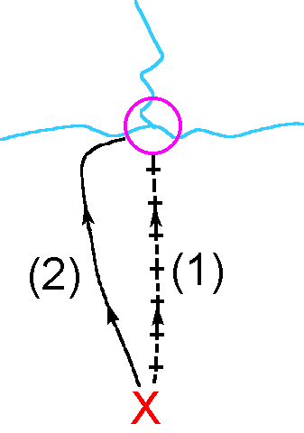 Aiming off is a technique allowing you to go on a bearing to an
obvious feature, which you can then follow in to the control. Suppose you have a
control on a stream junction and you are approaching it in a roughly
perpendicular direction from point X (figure 1). Instead of taking an accurate
bearing from X to the control and having to go slowly to make sure you keep on
the bearing (route 1), you aim for example to the left side of the control and
go on a rough bearing (route 2). This allows you to go faster to the stream and
you know you will need to turn right along the stream to locate the control. An
accurate bearing allows you to hit the control spot on and means you run the
least distance, but unless you are very accurate with your bearing you may end
up to the left or right of the control and then not knowing which way to turn
when you reach the stream.
Aiming off is a technique allowing you to go on a bearing to an
obvious feature, which you can then follow in to the control. Suppose you have a
control on a stream junction and you are approaching it in a roughly
perpendicular direction from point X (figure 1). Instead of taking an accurate
bearing from X to the control and having to go slowly to make sure you keep on
the bearing (route 1), you aim for example to the left side of the control and
go on a rough bearing (route 2). This allows you to go faster to the stream and
you know you will need to turn right along the stream to locate the control. An
accurate bearing allows you to hit the control spot on and means you run the
least distance, but unless you are very accurate with your bearing you may end
up to the left or right of the control and then not knowing which way to turn
when you reach the stream.
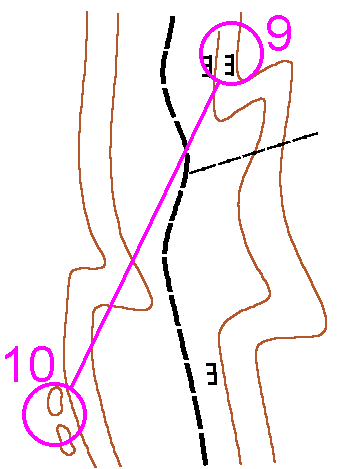 Attack points are very important in orienteering although in orange
courses and below you will not be aware you are using them as handrails lead you
to the controls. An attack point is an obvious point feature or crossing of 2
line features reasonably close to the control that should be easy to find. You
aim to find this first and then go more slowly into the control. Sometimes there
may be several possible attack points and it is up to you to choose the one you
think will be easiest to find and from which the control will be easiest to
find. This is not always as easy as it sounds. Figure 2 shows a fairly simple
example to illustrate what an attack point is:
Attack points are very important in orienteering although in orange
courses and below you will not be aware you are using them as handrails lead you
to the controls. An attack point is an obvious point feature or crossing of 2
line features reasonably close to the control that should be easy to find. You
aim to find this first and then go more slowly into the control. Sometimes there
may be several possible attack points and it is up to you to choose the one you
think will be easiest to find and from which the control will be easiest to
find. This is not always as easy as it sounds. Figure 2 shows a fairly simple
example to illustrate what an attack point is:
Control 9 is on a crag in a forest to the east of a path and control 10 is on a hilltop in the forest to the west of the path. To carry out this leg you will almost certainly want to use the path as a handrail for a large part of the leg. You could cut down to the path and then pace count as you head south on the path until you think you have gone the right distance before heading on a bearing into the forest to locate control 10. This is risky because you would have to be very accurate in your pace counting. Instead you should notice the crag on the east side of the path not far from control 10. You can run fast along the path until you see this crag at which point you slow down and take your bearing to control 10, the crag being your attack point. It should be easy to find and when you get there you know exactly where you are allowing you to take an accurate bearing to the hill top and control 10.
|
Provisional Training Programme |
||
|
Date/time |
Location |
Techniques |
|
14 Nov 98 10:00 |
Mildenhall |
Handrails, Aiming off, Attack points |
|
Dec 98/Jan 99 |
Mardley Heath, Welwyn |
Contour visualisation, Fine contour navigation |
|
Feb 99/Mar 99 |
Thetford or Maulden |
Simplification, Visualisation, (pairs using 2-way radios) Compass & pace |
|
May 99 |
Rowney Warren |
Route choice, Relocation |
|
Jul 99 |
Brecon Beacons |
Training weekend |
All these local training events will have a charge of about £2-00 per adult to cover the cost of maps and equipment. The date for the Mildenhall event is not yet confirmed so please contact me nearer the date to confirm the date and time.
Julia. (julia@cpd.ntc.nokia.com)
The officials for the WAOC event are:
Planner: Neil Humphries
Organisers: Tim Mulcahy and Alan Milne
Entries: Mike Gardner
A Controller has still to be appointed (for a badge event the Controller must not be from the organising club).
In consultation with CUOC (with whom we are combining to make the event a 2-day event on the 30/31 January 1999) a notice will be put into CompassSport advertising the events. The event will be named the 'Thetford Thrash incorporating the Icenian'. A special entry form will be supplied but a Standard Entry Form will also be accepted. The closing date for the event will be 3 weeks prior to the event, 10 January 1999
The provisional fees for the event will be
Seniors: 6.00 for one day 10.00 for both
Juniors/Students 3.00 for one day 5.00 for both
Ltd EOD + 1.00
There will also be a limited colour coded with entry on the day. It is also hoped to have a string course but this has not been confirmed.
The results from the Ampthill event have still to be added to the overall gallopen table so I am currently unable to include them in this edition. The addition of these results will also give a better indication as to which classes will have to be combined due to low numbers of competitors in them.
Next year it is hoped to use a new system to produce one league table of all club members that has been developed from the IOF ranking system for Elite runners.
The IOF ranking system has been developed to take into account the different running speeds between areas and the strength of the competitors attending an event. The formula that is used has been taken as a base and then expanded to fit a club setup which has the full range of age groups (i.e. not just M/W21E) and courses available (yellow to brown).
A description of the formula used and an interim league table showing what it would look like using this years results will be on display at the Bush Heath Wood event on Saturday, 7 November 98.
|
Junior Men |
|
|
|
Junior Women |
|
| ||
|
1 |
Steve Lawson |
WAOC |
834.70 |
|
1 |
Penny Bickle |
WAOC |
694.40 |
|
2 |
Neil Northrop |
WAOC |
632.28 |
|
2 |
Helen Bickle |
WAOC |
687.18 |
|
3 |
Peter Gardner |
WAOC |
436.48 |
|
3 |
Helen Gardner |
WAOC |
481.77 |
|
4 |
Simon Gardner |
WAOC |
412.04 |
|
4 |
Leonie Brown |
WAOC |
181.00 |
|
5 |
James Chapman |
?? |
166.00 |
|
5 |
Katy Woods |
WAOC |
166.28 |
|
6 |
Martin Humphries |
WAOC |
154.00 |
|
6 |
Clare Woods |
WAOC |
159.28 |
|
7 |
Edmund Brown |
WAOC |
153.00 |
|
7 |
Elizabeth Verdegem |
WAOC |
150.00 |
|
8 |
James Verdegem |
WAOC |
130.00 |
|
8 |
Louisa Gibbs |
?? |
130.00 |
|
Senior Men |
|
|
|
Senior Women |
|
| ||
|
1 |
Rolf Crook |
CUOC |
1,260.32 |
|
1 |
Nicola Gardner |
WAOC |
481.00 |
|
2 |
Ian Jones |
WAOC |
1,039.79 |
|
2 |
Julie Ferris |
SOS |
314.00 |
|
3 |
Ian Lawson |
WAOC |
975.34 |
|
3 |
Linda Gash |
WAOC |
286.95 |
|
4 |
Andrew Howard |
WAOC |
852.24 |
|
4 |
Catherine Ashton |
CUOC |
272.00 |
|
5 |
Russ Ladkin |
SOS |
835.95 |
|
5 |
Catherine Sowerby |
WAOC |
200.00 |
|
6 |
Dave Wotton |
WAOC |
714.52 |
|
6 |
Sue Woods |
WAOC |
200.00 |
|
7 |
Bob Hill |
RAFO |
632.00 |
|
7 |
Julia Carpenter |
WAOC |
157.00 |
|
8 |
Mike Gardner |
WAOC |
599.19 |
|
|
|
|
|
|
9 |
Peter Woods |
WAOC |
450.60 |
|
|
|
|
|
|
10 |
Roger Orpin |
WAOC |
378.00 |
|
|
|
|
|
|
11 |
Steve Williams |
WAOC |
282.00 |
|
Senior Men cont. |
| ||
|
12 |
Mark Johnson |
SOS |
239.00 |
|
17 |
G. Davies |
HH |
200.00 |
|
13 |
Steve Nobbs |
NOR |
242.15 |
|
18 |
Mark Collis |
CUOC |
181.00 |
|
14 |
Eric Roller |
CUOC |
200.00 |
|
19 |
Richard Gibbens |
WAOC |
143.00 |
|
15 |
Neil Humphries |
WAOC |
200.00 |
|
20 |
Ian Carter |
WAOC |
119.76 |
|
16 |
I. Renfrew |
?? |
200.00 |
|
21 |
Louis Verdegem |
WAOC |
100.00 |
|
GA Men (45+) |
|
|
|
GA Women (45+) |
|
| ||
|
1 |
Malcolm Humphry |
HALO |
767.80 |
|
1 |
Lindsey Freeman |
WAOC |
1,096.07 |
|
2 |
Chris Morley |
WAOC |
691.21 |
|
2 |
Noreen Ives |
WAOC |
571.86 |
|
3 |
Fred Northrop |
WAOC |
569.50 |
|
3 |
Hazel Bickle |
WAOC |
534.62 |
|
4 |
John Beadle |
WAOC |
540.92 |
|
4 |
Janis Ryall |
WAOC |
480.28 |
|
5 |
Roger Horton |
WAOC |
498.61 |
|
5 |
Ursula Oxburgh |
WAOC |
394.00 |
|
6 |
Guy Shirra |
WAOC |
488.60 |
|
6 |
Anne Duncumb |
WAOC |
321.40 |
|
7 |
Bruce Marshall |
WAOC |
411.48 |
|
7 |
Carol Hill |
WAOC |
237.22 |
|
8 |
Chris Bell |
WAOC |
300.00 |
|
8 |
Maureen Weldon |
WAOC |
200.00 |
|
9 |
Paul Hill |
WAOC |
296.61 |
|
9 |
Maria Marshall |
WAOC |
195.23 |
|
10 |
Mike Bickle |
WAOC |
281.79 |
|
|
|
|
|
|
11 |
Chris Thorne |
DRONGO |
259.51 |
|
|
|
|
|
|
12 |
Malcolm Mann |
WAOC |
200.00 |
|
GA Men (45+) cont. |
| ||
|
13 |
Chris Brown |
WAOC |
191.00 |
|
15 |
David Rose |
SMOC |
134.00 |
|
14 |
Tony Bishop |
WAOC |
160.00 |
|
16 |
Colin Curtis |
WAOC |
130.00 |
This is an effort league, therefore the more you do and get to the more points you get by a large margin. Planners and organisers get an automatic 200 points. All competitors get 100 points plus - The rest of the points are linked to times per km where possible.
Some non-WAOC competitors who have only turned up the once have not appeared above.
Our sport of Orienteering is all about trees in East Anglia - millions of them. Have you ever considered how many there must be in Thetford Chase, or even in Rowney Warren come to that? No, I don't know the answer to that one either. But it has taken a lot of time and a lot of effort to plant them and get them to the point at which we can use them and the land in which they're planted.
Have you ever considered helping to establish the orienteering woods of tomorrow? Now is your chance. Every year at about this time members of the Woodland Trust, of which there are many in the orienteering world, set out on Saturdays and/or Sundays to plant maybe 50, 100 or even 150 trees in the space of 3 or 4 hours. In 20 to 30 years time some of the woods so grown may just be right for you or your children to enjoy on a Sunday morning of orienteering. I remember flying over Morkery regularly 25 years ago when the trees were 6 to 8 feet high, and now they're just about to knock some of them down. However, this will never happen to Woodland Trust woods. They are meant to be planted to perpetuity, but the woods will still be managed to ensure a good mix of indigenous stock, whilst allowing differing types of flora and fauna to survive.
The planting dates for woods close to the WAOC area are;
|
Date |
Time |
Location |
|
Sat, 14 November 98 |
11:00 to 15:00 |
Land at Muchwood Lane, Ramsey, near Huntingdon |
|
Sun, 15 November 98 |
11:00 to 15:00 |
Plummers Lane, Haynes near Bedford, just adjacent to Maulden Wood |
|
Sat, 21 November 98 |
11:00 to 15:00 |
Priory Wood at Burwell, north-east of Cambridge |
|
Sun, 7 February 99 |
11:00 to 15:00 |
Wandlebury just south of Cambridge adjacent to the Gog Magog hills. WAOC have used this area in the past before the great '87 storm blew the mature beeches down. There is a copse of trees here dedicated to Anne Bishop late a member of our Club. |
More details can be obtained direct from the Woodland Trust by phoning (01476) 581149.
The Woodland Trust is generally very anxious that members of the public have access to Trust woods, despite SSSI's. And we as orienteers have enjoyed a number of them. This is a way we can help our communities the Country and ourselves at large. May I commend this exercise to you all. You don't need to take your own 'weaponry', but it would still be a good idea - forks and spades.
Hally
To provide a structured development of the skills required to be a competent orienteer, BOF have developed Guidelines detailing the technical difficulty appropriate for each course and age group.
The technical difficulty of a course is based on the skills needed to successfully complete it. The aim of Planners should be that the courses at an event show clearly the progression of technical difficulty, with each course providing the correct level of technical and physical challenge.
The technical difficulty of a course is that of its hardest component. For example, a course is of technical difficulty 3 even if it has just one element at that difficulty, even though the rest may be easier. However, a well designed course of technical difficulty 3 will have most, if not all, of its elements at that difficulty.
The following section describes what skills and techniques are expected at each technical level. It also details the colour-coded courses, lengths and badge age classes that are appropriate for each level of technical difficulty.
Firstly, a few basic definitions:
|
Route choice |
The option of taking more than one (sensible) route between two controls. This may, for example, be a choice of two different path routes or one of a (longer) path route versus a direct cross-country route. |
|
Decision point |
A point at which you can no longer continue in the same direction, e.g. being required to turn right at a path junction. A decision point on a leg does not imply a route choice. There may be only one obvious route between controls but this would require the ability to change direction at a number of decision points. |
|
Collecting feature |
A large feature beyond a control that, when reached, informs the competitor that the control has been missed. This will usually be a line feature, e.g. a path, fence or steam. |
|
Relocating feature |
A distinct feature that may be used by competitors to identify their position both on the ground and on the map. |
|
Course |
Skills |
Techniques |
Routes |
No. Controls |
Control Sites |
Relocation |
|
White, 1.0-1.5Km TD = 1 M/W10B |
|
|
|
|
|
|
|
Yellow, 1.5-2.5Km TD = 2 M/W10A M/W12B |
|
|
|
|
|
|
|
Orange, 2.5-3.5Km Red, 3.5-7.5Km TD = 3 M/W12A M/W14B |
|
|
|
|
|
|
|
Course |
Skills |
Techniques |
Routes |
No. Controls |
Control Sites |
Relocation |
|
Light Green 2.5-3.5Km TD = 4 M/W14A M/W16B |
|
|
|
|
|
|
|
Green, 3.5-5.0Km Blue, 5.0-7.5Km TD = 5 M/W16A M/W18B |
|
|
|
|
|
|
|
Brown, 7.5-10.0Km TD = 5* M/W18A and above |
|
|
|
|
|
|
Colin West (SOS), the Junior Squad Co-ordinator, is seeking new junior members who have the ability to orienteer to at least Orange standard and are committed to progressing further. If any junior wishes to join they should contact Colin. Phone number removed from online edition.
Lottery Funding
The region is proposing to apply for funding to obtain electronic punching for the region.
EA Championships
These will be held at the WASH badge event at Sandringham on 28 March 1999.
Junior Inter Regional Championships 2000
The proposed date is 2/3 July 2000. NOR will be organising the individual day, probably on the Norfolk coast with overnight accommodation in the Thetford area. The relays will be organised by WAOC/SUFFOC in the Thetford area.
Tripods
The use of tripods should be described in the event information as to their composition and size.
Next meeting: 13 November 1998
Maulden needs updating before the December event, any volunteers?
Finance
WAOC subscriptions for 1999 are to be unchanged.
Coaching
Applications for funding to attend coaching courses by club members will be considered on their merits. It would be made clear that funding is available only where the intention is to use the skills acquired for the benefit of club members.
Schools league
WAOC will be staging the relays at Ampthill on 26 May 1999 plus one other event during the summer.
Colour Coded Awards
Ursula Oxburgh has agreed to take over this role
Next meeting: 1 December 1998
|
Bush Heath Woods Saturday, 7 Nov 98 The date shown in Points East is incorrect. O signed from Barton Mills roundabout (A11) (White to Brown) Enquires: Lindsey Freeman |
|
Tuesday, 3 November 1998 @ 19:30 Hosts: Anne and Peter Duncumb For more details please contact |