West Anglian Orienteering Club
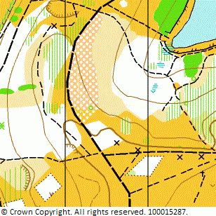
Ampthill Park map
Near: Ampthill

Description
Terrain Description:
Contoured parkland on the Greensand Ridge with some areas of runnable woodland. Suitable for local and limited-scale regional events.
Map Scale: 1:5000
Map Format: A4
Location
Nearest Town: Ampthill
Postcode: MK45 *
Lat,Lng: 52.03204,-0.50845
Grid Ref: TL024382
Open an interactive map in a new tab using:
* Postcodes are not very precise in some areas, so don't rely on them for an exact location.
Images from the areaclick/tap photos for a larger version
Ampthill Park